Driving Through Time: The Digital Blue Ridge Parkway
Posted: January 23, 2012 Filed under: Web Map Examples | Tags: blue ridge parkway, examples, historic maps, north carolina, photographs Comments Off on Driving Through Time: The Digital Blue Ridge Parkway The University of North Carolina has developed an awesome way to explore historic photographs and maps of the Blue Ridge Parkway. Driving Through Time features two web maps that serve as the primary means of exploring their digital catalog of photographs and scanned paper maps.
The GeoBrowse map uses OpenLayers as the client-side mapping API and Google’s base map tiles to serve as the backdrop. The individual markers are clustered at lower zoom levels, as a large number of markers would clutter the display. Clicking on a cluster marker will bring up a slideshow of images found within the clicked cluster below the map, which is a nice touch. Usually, many map developers use the cluster to support a pop-up map window/balloon; to me, the balloon is not as easy to navigate as what they have done here. Another nice touch of the GeoBrowse map is the ability to filter the map markers by category or date range. The filtering is being performed server-side, which requires a reload of the page. Personally, I would perform the filtering client-side in JavaScript or use an AJAX call, that way you do not need to reload the page each time a new category is selected.
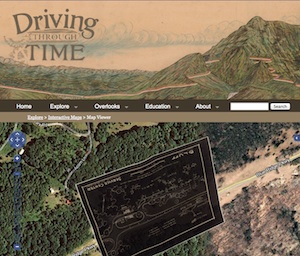
The link titled “Interactive Maps” brings you to a listing of historic maps that have been scanned in and georectified to align with the base map and imagery provided by Google. The map uses a slider control to adjust the opacity of the overlay image, which allows the user to easily view the differences between the aerial photography and the historic map. This map of the Bluff Service Center has some cool hand-lettering, but because the map was not oriented to north, it’s upside down! Very few JavaScript APIs support non-North orientation at this time, so unless you use a more robust platform, such as Flash/Flex or the Google Earth API, you’re stuck with North oriented maps.The upside here is that they provide a KML file for each map, which will allow you to bring the scanned map into Google Earth. By the way, the scanned maps are then projected into the Spherical Mercator projection, and then cached. These cached map tiles are then made available through a Tiled Map Service (TMS) server.
Driving Through Time is a great example of making information accessible using web maps. These documents have likely been with the UNC Library system or the State of North Carolina for years, unseen by the public because they existed only as hard copies. Now that they are available through a web map, you can explore the history of the Blue Ridge Parkway from anywhere in the world.

Recent Comments